
Hurricane Erin Disrupts North Carolina’s Outer Banks in August 2025
Hurricane Erin has forced tourists to cut their vacations short along North Carolina’s Outer Banks, despite forecasts indicating the storm will likely remain offshore. Having already affected parts of the Caribbean with heavy rain and winds on Monday, Erin prompted evacuations on several barrier islands due to anticipated dangerous rip currents and towering waves up to 15 feet (4.6 meters).
On Monday, Tropical Storm and Surge Watches were issued for vast areas of the Outer Banks. Authorities reported rescuing over 60 swimmers from rip currents at Wrightsville Beach, near Wilmington. Tourists faced long waits at the Ocracoke Island ferry dock, the sole route out besides air travel.
Seth Brotherton from Catfish, North Carolina, lamented that his weeklong fishing trip transformed into just a two-day excursion due to the mandatory evacuation order. “When they say ‘mandatory,’ it’s clear you need to leave,” he stated.
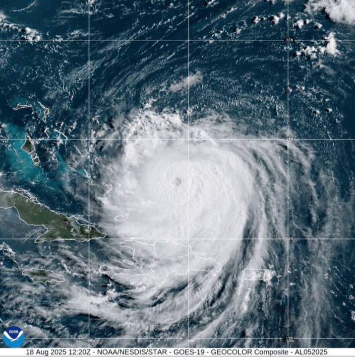
While experts expect Erin to veer northward away from the U.S. east coast, high waves and tropical winds are still likely to impact the coastal islands, according to Dave Roberts from the U.S. National Hurricane Center in Miami. The storm reached a Category 4 status with maximum sustained winds of 140 mph (225 kph) while battering the Turks and Caicos Islands and the southeastern Bahamas. By Monday evening, its winds had diminished to 125 mph (200 kph), with the storm located approximately 690 miles (1,110 kilometers) southwest of Bermuda.
In the Turks and Caicos, government officials suspended all services on three islands and advised residents to remain indoors. Coastal flooding along North Carolina’s Outer Banks is projected to commence on Tuesday and persist through Thursday.
The evacuation orders implemented on Hatteras Island and Ocracoke arrive during the peak tourist season for this vulnerable stretch of barrier islands that extend into the Atlantic. Last year, Hurricane Ernesto spared the mainland yet still created hazardous surf conditions that caused coastal erosion. Authorities are concerned that prolonged heavy surf and high winds could damage Highway 12, potentially rendering key routes impassable for days.
This marks the first evacuation of Ocracoke since Hurricane Dorian in 2019, which inflicted record damage on the island. Grocery store owner Tommy Hutcherson expressed hope that the current storm will not be as devastating. “But you can never be too sure. I felt the same optimism with Dorian, and it hit hard,” he said.
Experts link the rapid intensification of hurricanes like Erin to climate change, attributing it to rising ocean temperatures and increased atmospheric moisture. Daniel Pullen, a professional photographer residing on Hatteras Island, has already missed three days of work due to the evacuation order but opted to stay put, fearing he could be stranded for weeks if key roads are washed out. “It feels like a gamble—stay and risk the storm or leave and risk being stuck away for who knows how long?” Pullen noted, emphasizing that most locals cannot afford hotel stays during prolonged evacuations.
As the first hurricane of the Atlantic season, Erin initially reached Category 5 status with winds of 160 mph (260 kph) before weakening. The storm will pose a significant threat to Bermuda by Thursday evening, with wave heights potentially reaching 24 feet (7.3 meters). Authorities are urging surfers, swimmers, and boaters to stay out of the dangerous waters.
Erin’s outer bands have already impacted Puerto Rico and the Virgin Islands, unleashing heavy rainfall and tropical winds, resulting in power outages for thousands.
This report integrates information from Associated Press journalists Safiyah Riddle in Montgomery, Alabama, and Julie Walker in New York.