
NEW YORK (WPIX) — The return of a significant “warm blob” in the Pacific Ocean could have substantial implications for this winter across the United States.
A Record-Breaking Marine Heat Wave
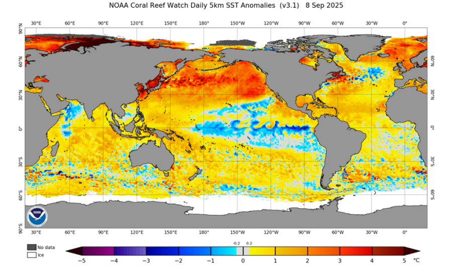
This summer, a formidable warm water anomaly has formed off the coast of Alaska, raising alarms about its potential effects on marine ecosystems and broader weather patterns across the continent.
The National Oceanic and Atmospheric Administration (NOAA) reported that North Pacific sea surface temperatures soared to 20°C (68°F) in August, marking the highest levels ever recorded. For context, the previous notable threshold of 19°C was first crossed just over a decade ago, with records tracing back to 1854.

Abnormal warm water spans the entire Northeast Pacific. (Credit: NOAA)
This event is now recognized as the fourth-largest marine heat wave since 1982, stretching across an extensive area from north of Hawaii to the coasts of California and Alaska.
Threats to Marine Ecosystems
The surge in ocean temperatures is having adverse effects on marine life. Warmer waters can lead to a range of issues, including:
- Disruption of feeding patterns for various marine species
- Increased occurrence of harmful algae blooms
- Enhanced stress on ecosystems along the coasts of California, Washington, and Oregon
A recent study by the University of Washington published in Science highlighted the devastating impact that similar warm conditions had from 2014 to 2016, which coincided with the deaths of approximately 4 million common murres in the northeastern Pacific.
These ecological ramifications could extend into the realm of commercial fisheries, local economies, and the overall biodiversity along the coastlines in the upcoming months and years.
Shifting Weather Patterns: Implications for Winter
From a meteorological standpoint, this situation could significantly influence the coming winter. The presence of this warm anomaly typically prompts high-pressure ridges to form over the Pacific Northwest, nudging the jet stream eastward and often allowing frigid Arctic air to sweep into the eastern U.S.
This developing scenario bears a striking resemblance to the winter of 2013–2014, characterized by:
- A neutral-to-weak La Niña ENSO pattern
- Below-normal hurricane activity in the Atlantic
- Major cold waves and substantial snowfall across the Northeast
During that winter, New York City recorded an impressive 57 inches of snow, while Philadelphia saw 63 inches. The following winter, Boston broke records with a staggering 110 inches of snowfall.
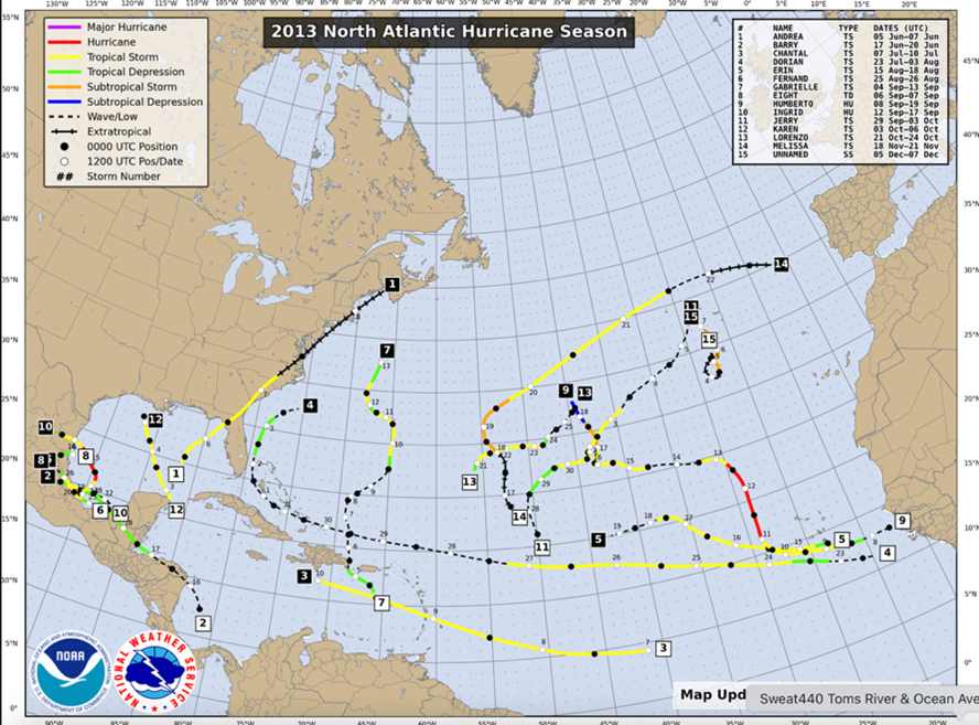
NOAA 2013 Hurricane Season/Activity data showing below-average activity. (Credit: NOAA)
Is History About to Repeat Itself?
The current conditions in the ocean and atmosphere closely mirror those from the winters of 2013–2014, prompting concerns of yet another severe winter for the East Coast, particularly given the below-normal hurricane activity observed so far this season.
As forecasts develop, the resurgence of the Pacific “Warm Blob” serves as a crucial warning for both scientists and weather enthusiasts moving forward.